The US was spared this hurricane season. Here's why.
- Last update: 4 days ago
- 3 min read
- 29 Views
- USA
Earlier this year, meteorologists forecasted a busier-than-usual hurricane season for the Atlantic, expecting nine to ten named storms, with four potentially reaching major hurricane strength. Remarkably, the season concluded without a single hurricane striking the United States, a first in ten years. While this outcome was positive for the U.S., the season also brought significant challenges elsewhere.
Experts predicted the season by examining several key factors. Hurricanes draw energy from warm ocean waters, and the Atlantic had been exceptionally hot, providing ample energy for stronger storms. Brian McNoldy, a hurricane scientist at the University of Miami, noted, The main consideration going into the season was just very, very warm ocean temperatures, either record-breaking in parts, or close to record-breaking.
Meteorologists also accounted for the Pacific Ocean's climate cycles, which can be warm (El Nio), cold (La Nia), or neutralas it was this season. El Nio typically suppresses Atlantic hurricane activity by increasing vertical wind shear, while La Nia promotes storms by reducing it. This year, the neutral conditions suggested an average season.
However, atmospheric patterns over the U.S. introduced an unexpected twist. The jet stream, a high-altitude air current with ridges and troughs, played a key role. Ridges are associated with calmer weather, while troughs bring storminess. From August through October, instead of a typical ridge over the southeastern U.S., a trough prevailed. This produced counterclockwise wind motion in the mid-atmosphere, effectively steering hurricanes away from land and back into the Atlantic. McNoldy explained, As they approached the East Coast, we had this anomalous influence this hurricane season, where they were more or less steered to the north by that anomalous trough.
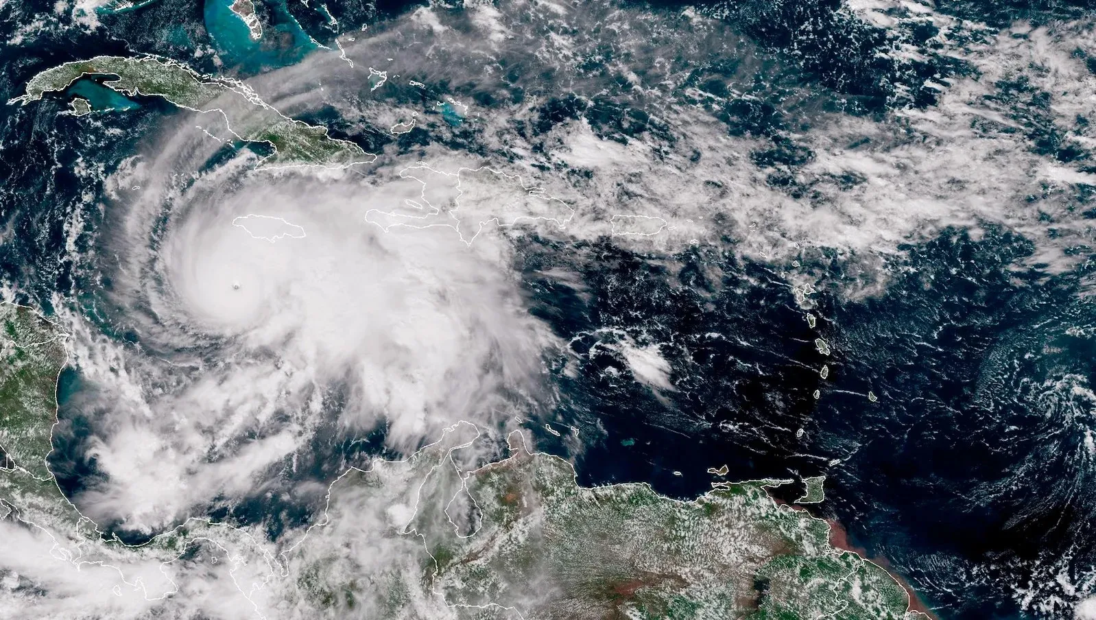
The Caribbean, however, faced devastating impacts. Hurricane Melissa claimed at least 45 lives in Jamaica before passing over Cuba, Haiti, and the Dominican Republic. As the storm moved slowly across the Atlantic, it drew energy from unusually warm watersconditions made up to 900 times more likely by climate changeboosting its wind speeds by 10 mph. Though seemingly small, this increase significantly amplified potential damage.
Typically, hurricanes churn ocean waters, bringing cooler water to the surface, which limits their energy. In Melissas path, deeper ocean layers were also abnormally warm, sustaining the storms strength. This allowed Melissa to rapidly intensify, doubling its wind speed from 70 to 140 mph in just 18 hours, ultimately reaching 185 mph. It tied for the second-most powerful Atlantic hurricane on record and became the strongest to make landfall.
The 2025 hurricane season was unusual in several ways. Only five Atlantic hurricanes formedhalf the number forecastedyet four reached Category 5 intensity, including Melissa. With an average season producing seven named storms and 40 percent reaching Category 5, this years 80 percent is highly exceptional. While the U.S. avoided landfalls for the first time since 2015, this is only the second recorded year with three or more Category 5 hurricanes.
This trend underscores the growing impact of climate change: warmer oceans provide more energy to fuel intense storms. Even if atmospheric conditions occasionally shield the U.S., hurricanes that do strike will likely become stronger and more destructive in the future.
Author: Sophia Brooks
Share

Space Force Awards Contracts for Golden Domes Ahead of Schedule
3 days ago 3 min read USA

Police called after student brought a skean dhu to school
3 days ago 1 min read USA

Police raid 'successful' mail-order drugs operation
3 days ago 2 min read USA

Man admits to killing Ole Miss graduate 10 months after her body was discovered
3 days ago 3 min read USA

Over 55 million Americans warned of snow and ice from Kentucky to Maine
3 days ago 2 min read USA

Reinsurance giant reports mild end to hurricane season, US and Japan spared
3 days ago 2 min read USA

Funny Video Shows Gold Retriever's Love for His Lost Ball Outweighing Owner's
3 days ago 2 min read USA

New landlords reopen historic community pub
3 days ago 2 min read USA

Tom Brady advocates for a new national holiday in popular advertisement
3 days ago 2 min read USA

The Best Coastal Small Town in the U.S. Is This Quiet Florida Destination
3 days ago 4 min read USA