The Five Men Who Surveyed Mount Everest
- Last update: 3 hours ago
- 4 min read
- 321 Views
- TRAVEL
Lambtons Foundational Baseline
The journey to measuring Everest began not in the Himalaya, but on a flat coastal plain south of Madras in 1802. On April 10, Lieutenant William Lambton, an East India Company officer, started establishing what would become a famous surveying baseline. Using a 30.48-meter steel chain adjusted for temperature, Lambton and his team meticulously laid out a line over 12 kilometers, measuring each segment three times forward and three times backward. The final probable error was under 5 centimeters.
This baseline formed the starting point for a network of massive triangles stretching north toward the Himalaya, as part of the Great Trigonometrical Survey. Lambton aimed to create accurate maps for administration and to measure a long meridian arc to refine knowledge of Earths shape. The work was painstaking, with observation points on hills, temple towers, and specially constructed platforms, and angles measured only during calm early mornings or nights.
Lambton carried the survey north through central India, but he died of fever in January 1823, having extended the survey over 1,600 kilometers. The Himalayan peaks still lay far beyond reach.
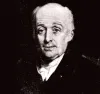
George Everest Takes Command
Sir George Everest inherited Lambtons vision and refined it with extraordinary precision. Born in Greenwich in 1790, Everest excelled in mathematics and astronomy and joined the survey in 1818. He became superintendent in 1823 and Surveyor General in 1830. Unlike Lambton, Everest was meticulous, revising earlier triangles, introducing compensation bars to account for chain expansion, and requiring multiple observations by independent observers.
Everest also introduced the Great Theodolite, a nearly 1.5-meter-high instrument capable of measuring angles to a single second of arc. Transporting it demanded dozens of porters and sometimes elephants. Under his leadership, progress slowed, but accuracy reached unprecedented levels. By 1841, the survey had reached Dehradun, near the outer Himalayan ranges. In 1843, Everest retired, never witnessing the ultimate success of his work.
Field Observations in the Terai
Surveying the Himalaya required observation from the Indian side, as Nepal remained closed to Europeans. Towers of bamboo up to 30 meters high were built for the theodolite, and observers endured malaria and dangerous wildlife. Captain James T. Nicolson of the Bengal Infantry oversaw the operations in 18491851, establishing six key stations over a 300-kilometer baseline. From these points, angles were measured to numerous peaks, including Peak XV. The measurements required repeated readings to account for minute horizontal angles and delicate vertical angles influenced by atmospheric refraction. Nicolson eventually succumbed to malaria and died in 1857, though his field notes survived.
Radhanath Sikdar and the Computations
Back at survey headquarters in Mussoorie and later Dehradun, Radhanath Sikdar and his team converted Nicolsons measurements into heights. Sikdar, born in Calcutta in 1813, had joined the survey in 1831 and by the 1850s led the computation department. Correcting each observation for errors, atmospheric refraction, and Earths curvature, they worked with extreme precision over several months. In 1852, Sikdars calculations revealed that Peak XV exceeded Kangchenjunga by at least 150 meters, approaching 8,839 meters above sea level.
Andrew Waughs Verification
Surveyor General Andrew Scott Waugh, who had succeeded Everest in 1843, rigorously verified Sikdars results. Additional observations were made, calculations were independently repeated, and by 18541855, Waugh was confident enough to publish the mountains height. He added 0.6 meters to avoid a rounded figure, reporting 8,839.8 meters and proposing the name Mount Everest in honor of his predecessor. Everest, residing in London, preferred a local name, but the decision was finalized.
Legacy of the Measurement
The height of 8,839.8 meters remained official for nearly a century, refined slightly in the early 20th century and again in the 1950s. Modern measurements using advanced geodesy and GPS now list Mount Everest at 8,848.86 meters (ChinaNepal agreement, 2020). The discovery of Everests exact height was a culmination of Lambtons initial baseline, Everests precision, Nicolsons field efforts, Sikdars calculations, and Waughs verification a six-decade collaborative achievement involving five remarkable individuals.
Author: Lucas Grant